Environmental safety of a territory due to the dangerous processes of flooding.
 Olena Voloshkina 1,
Julia Bereznitska 2*
1 D.Sc., Professor, Head (BrE) of Occupational Safety and Environment Department, 2 Postgraduate at Occupational Safety and Environment Department of Kyiv National University of construction and architecture, Kyiv Ukraine.
Received: 08/05/2017, Accepted: 08/25/2017, Available online: 09/30/2017.
DOI: https://doi.org/10.32557/useful-1-1-2017-0003
HDL: http://hdl.handle.net/20.500.12334/26
*Corresponding author: e-mail: juli_mmm@ukr.net,
address: Povitroflotsky Avenue, 31, Kyiv, 03680 Ukraine
Under a creative commons license. Volume 1, Issue 1, 2017, pages: 21-33.


Author Keywords: environmental safety, flooding, ground water.
Abstract. They determined the way the dangerous factors caused by the processes of flooding influence on environment and living conditions, they are the following: they estimated water resources quality, violation of water balance conditions on the flooded territories (the loss of drainage capacity of rivers and underground drainage formation), the process of activation of dangerous exogenous processes, they also theoretically grounded the necessity of correction of calculation method of filtration flow with the use of filtration resistance.
On the basis of these researches they gave recommendations according the usage of widespread methods of filtration resistance for difficult geological conditions of water-bearing layer and stationary filtration flow near the facilities of engineering protection from flood.
Mathematical model of forecasting of ground water level changes in aquifer with the level fluctuations in water receiver on conditions of three-ply water-bearing layer allows to make a reliable assessment and the forecast on flood level of a sloping hill which, in turn, allows to make promptly a managerial nature-green decision on provision of a territory with the necessary level of environmental safety.
The method of estimation of individual risk on the built-over flooded territories by taking into account the slopping hills was improved.
- Introduction
For last 30 years the square of flooded areas on the territory of Ukraine has increased almost 9 times and at present moment it is 20% of our country's territory. One of the most important tasks on satisfactory environmental safety level of a territory is its prevention from the flooding of settlement territories and the rectification of the consequences which are provided by The state program on development of water and ecological recovery of the Dnipro river basin on the period till 2021, which is a part of the Complex program of rural points and farmlands protection from harmful water effect (with the changes by CMU from 18.07.12). An integral part of this task is the creation of a reliable base of engineering estimations relying on assessments and forecasts of conditions of filtration flow formation on the flooded territories aimed for construction and reconstruction of drainage systems which protect settlements from flood.
Today theoretical and experimental research work on influence of modern mechanisms of regional flooding and soils pollution on the level of environmental safety of territories but when determining the environmental measures on the territories protection with the built-over hills the conditions of ground water formation are not adequately investigated and are mainly limited to the definition of filter flow specifications basing on simple physical and mathematical models with substantial systematization of natural and, especially, hydrogeological conditions of the territory. The existing methods for calculation of inflowing steams to the protective structures (vertical drillholes system, horizontal drainage systems) using them on conditions of difficult multi-layer aquifers and transient regime of ground waters can give reliable results, as a rule, only in limited cases. That is why it is important to develop more grounded methods of calculation of protective drainage facilities in particular on landslide territories with more complete consideration of groundwater move under the hydrogeological conditions close to real ones with improvement of methods calculating the individual risk of living on flooded areas.
- Material and Result of Research
The assessment and forecast of influence of flood processes on environmental safety of the territories was studied by the following well-known authors: Rud'ko G.I., Mykhailov Y.O., Yakovlev E.O., Savchuk D.P., Romanenko.M.I., Kovalchuk P.I., Trofymchuk O.M., Krasovskyi G.Y., Oliinyk O.Y.,Bilyavskyi G.O. and others.
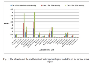
Taking into account the scoring method of estimation of integral impact of considerable factors on water resources safety (Grodsyns'kyi M.D., Yatsyk A.V., Yakovlev E.O.) they made the zoning of the territory of Ukraine on water and ecological load (Cw.e.l) for different years of provision, when the Coefficient Cw.e.l is determned from the correlation Cw.e.l=Qgen./(Qsur.+Qunder.), when Qgen. - general scope of water consumption; Qsur. - surface water resources; Qunder. -underground water resources (together with prof.Yakovlev E.O.)
They also have analyzed the impact of flooding on the quality of the surface water resources of Ukraine by putting on the flood map the parameters of surface water quality.
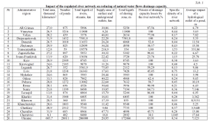
The assessment of impact of flood processes on the hydrological budget of the areas, in particular on its constituent part as the underground off-flow, resulting the filtration processes impact on the flow capacity (tab. 1).
In general the conducted researches of technogenic surface and underground water cycle and the interact factors of surface and underground water (Shestopalov V.M., Yatsyk A.V., Drobkokhod M.I., Golberg V.M. and others) evidences that all consistencies of the interaction of rivers basins and underground rivers basins are known. But the assessment of influence of flooding at present stage of its development with the fragmentary monitoring of surface and underground hydrosphere has rather mediate character. Today it is the main factor for reconstruction of water-energy-exchange in geological environment and its ecological parameters - from the quality of food chain to the activation of dangerous exogenous geological processes (landslides, drainage, karstic etc.) and seismic-geophysical ones (increasing during earthquakes) technogenic hydro-geo-deformational zones in cities etc.).
Influence of flooding on the quality of surface and underground waters is in multiple acceleration of migrations (including natural ones) of technogenic pollutions which demands the structural and quantitative parameters of the process to be studied.
The results of the data assessment showed that the issue of increasing of the flooded territories environmental safety needs to be carefully studied due to the connection with the danger of landslides, flow rate of rivers channels, which, in turn, decreases the underground outflow on the flooded territories. In order to solve the task it is necessary to examine gradually the formation of filtration flow on the flooded territories.
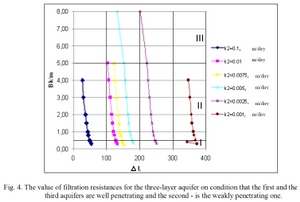
Analysis of the calculation methods of the ground flow formation basing on method of flow coefficient which is widely used in calculating of protective drainage facilities (in the studies of Oliinyk O.Y., Polyakov V.L., and others) shows that its appliance in conditions of filtration from wide nonperfect channels and protective facilities considering difficult geological construction of aquifer we receive increased numbers of flow coefficient which leads to the decreasing of calculated characters of ground water level (to 20%). Such conditions exist when calculating poldern reservoirs, built-over hills, and the hills in which communication networks for different purposes are set etc. If you ignore this factor it can lead to emergency situations as well as to other negative consequences. By using the existing interrelations and the suggested recommendations the graphs of the indicators changing of filtration resistances were constructed ΔL for different hydrogeological structures of the hills considering the width of drainage channels Bk, capacities of water-bearing layers m and aquifers filtration coefficients k, which are given at the Fig. 2 - 4.
Herewith the inflow is calculated in three zones: zone I - by the analogy with the round drain in the cases with open channels with small width in correlation to the bottom


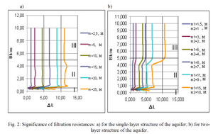
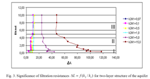
The conducted calculation allows making the following conclusions:
- for homogeneous layer the indicators


- simplifying of the two-layer aquifer to the single-layer type


of the simplifying of the aquifer two-layer construction to the single-layer one conduct the decrease in value of filtration resistences and in such cases the calculation of the ground water level is conducted with conservative value ;
- to bring the two-layer aquifer to the homogeneous mass using the method recommended by the scientists you should apply carefully the correlation
- when there is a three-layer construction of an aquifer the indicators of filtration resistances mostly depend on the indicators of the coefficient of filtration of the middle weakly penetrating layer

- if the channels are wide

Here is an analytical solution to the problem considering non-standard filtration of an open drainage channel in the slope on condition of three-layer aquifer.
As a rule the same schemes were considered in approximate hydraulic setting which was based on the methods of filtration resistances. In more precise hydraulic setting the solving of the same problems came down to the equations and boundary conditions which were fulfilled for the flow with free surface when there was additional nonlinear condition which described the character of its moving in time. Some decisions approximate to non-standard tasks of non-pressure filtration in hydro dynamic setting are known in scientific literature that are solved mostly for the cases with homogeneous aquifer (Polubarinov-Kochin P.Y., Verigin M.M., Oliinyk O.Y., Poliakov V.L.).
They received the solving of the problem of non-standard filtration in drainage channel in the slope. The filtration area of three-layer construction of an aquifer with free surface is divided into 7 fragments in the upper layer (fig. 5). In every fragment on condition of hard filtration mode (without considering the spring properties of water and rocks) the two-dimensional filtration flow is being described by the famous equation by Laplace considering the filtration speed potential. The solving of the Laplace's equation is made in every fragment by using the known boundary conditions on external and internal boundaries, in particular there were set the known boundary conditions of the 4th type on internal boundaries, they characterize the continuity of flows and filtration speed.
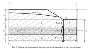
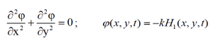
The result of the mentioned filtration task is the definition of free surface location in the upper layer (fragment 1). In this case we use Laplace's two-dimensional equation:
(1)
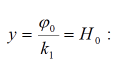
It is solved on the linear condition on the free surface which is set on the horizontal line
(2)
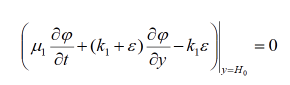
When φ (x, y, t) - filtration flow speed potential;
H(x,y,t) - level (hydraulic drop) of groundwater in upper free-gravity layer, m;
H0 - ordinate of horizontal surface in which the ground water surface is changed approximately at the present moment of time, m;
k1 - coefficient of upper ground layer filtration, m/24h;
μ1 - coefficient of water return in the ground upper layer;
ε - infiltration nutrition of ground water to the free surface, m/24h
We should notice that in this case the external boundaries of filtration area are not perfect that is why we except the boundary conditions of the 3-d type
As a result of this filtration task solving by using mathematical methods which are given in the dissertation work the equations for tracing of the curve depressing in time in the slope drainage channel on conditions of three-layer construction of an aquifer:
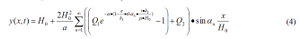
when Q1 and Q2 - parameters which depend on the correlation of filtration coefficients, capacities of aquifer layers, filtration resistances and geometrical parameters of a filtration scheme.
In this study we provide the example of calculation by the suggested formula for particular situation of filtration in the flooded slope, the comparison of which with the existing approximate calculation method showed the correlation of the received indications of 5-7% that point at the reliability of the received method.
The obtained relations of filtration flow formation in the slopes of the regulated water reservoirs allow to make more precise forecasts for their constancy depending on reservoir storage which, in turn, allow to make the environmental decisions in time for improvement of ecological safety on flooded territories.
Basing on the analysis and proceeding of the data considering increasing of the flooded areas and the number of landslides in the period of 20 years the statistical correlations on the most typical for the regions of Ukraine were determined. Basing on these correlations they suggest the coefficient of landslides activation (KLA) as a function from the increased number of active landslides alongwith the flooded territory under consideration.
Previously the factor of flooding of landslide slopes was considered when calculating the environmental risks in the coefficient of technogenic activation of IEPG which includes the total influence of technogenic factors of industrial and urban agglomerations and the value of which is suggested to accept from 1,5-20 to 5-10 depending on local objects of IEPG development. But according to the statistical analysis of flooded indicators data during more than 20 years the flooded and landslides indicators on the territory of Ukraine, the very impact of the flooded factor separately can increase individual risk of life ten times on the flooded territories which are in danger of landslides (the regions of Kharkiv, Vinnytsia, Chenivtsi, Zaporizhzhia).
So, the total formula for estimation of individual risk of living on landslide flooded slopes is:
(5)
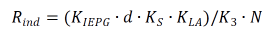
When d and N - accordingly the density of population and total population within the territory under study; KIEPG - annual probability of dangerous geological processes occurrence.
K3 - coefficient which considers the stabilizing effect of the system and the methods of engineering protection (as a rule, they are calculated for 30 years); Ks. - coefficient which considers the building density on the territory that is in danger of landslides within the bounds of a territory assessment.
Conclusions
- We have analyzed the development of the flooded processes on the territory of Ukraine during 30 years, we also have carried out the analysis of factors which affect the development of this process.
- We have studied the factors that affect the losses of drainage capacity of natural water resources and the formation of underground outflow basing on the results of analysis of main characteristics of regional flooding process activation.
- We have determined the impact of flooding processes on the quality of surface water resources using the analysis of flooding processes development on the territory if Ukraine during 30 years and the changes of quality of surface water resources. It was created a map of interconnections of flooded process development and surface water quality by main indicators.
- We also have defined the dependence between density of river network, level of ground water and the activation of the landslides processes on the territory of Ukraine.
- We have theoretically grounded the necessity of correction of filtration resistances methods caused by non-complete cover of an aquifer by drainage channel on condition of flooded areas for different construction of an aquifer and soils filtration characteristics.
- On the basis of theoretical decision of the mathematical model of non-stationary filtration on conditions of difficult hydrogeological construction of a slope it was obtained the method which gave an opportunity to make accurate forecasts of depression curve position in the flooded slope with its difficult construction for making environmental decisions on the flooded territories in time.
- We have suggested the improved methods for calculation of individual ecological risk of living on the flooded territories under threat of landslides considering the impact of flooding development on the landslide processes activation which allows to make managerial environmental decisions in time.
References
[1] Voloshkina O.S., Bereznytska Y.O. “Impact of flooding processes on filtration flow formation in the slopes of the regulated reservoirs”. - Ecological safety and natural resources utilization. - 2013. - No.13. - P. 62-67.
[2] “Probabilistic automated simulation in the research of migration processe in soils”. O.A. Kotovenko, O.Y. Miroshnychenko, Y.O Bereznytska, Y.V. Shostal. - Eastern European magazine of innovative technologies. - 2014. - No.70. - P. 37-43.
[3] Kaliukh T.Y., Dudarenko A.I and others. “Modern informational analytical systems of decision making support providing the sustainable development of territories. Methodological manual”. - Kyiv: Znannia, 2000. - 32 p. - (2000).
[4] “National speech on the state of technogenic and natural safety in Ukraine in 2012”. [ Electronic resource]. - Kyiv: SE "Chornobylinterinform". - 2013. - P. 542. -Access mode:http://www.mns.gov.ua/content/annual_report_2013.html
[5] Numerov S.N. “Methods of mathematic modelling of the planned unsteady filtration of ground water”. - Studies of coordination meetings on hydraulic engineering, Lviv.: "Energy". - 1966. - No.15. - P. 124–138.
[6] Numerov S.N., Barsegian R.M. “About additional filtration resistances of an imperfect drainage (horizontal and vertical) in the case of fluid filtration in the hydraulically connested layers”. - Studies of coordination meetings on hydraulic engineering, "Energy". - 1966. - No.15. - P. 76-91.
[7] Oleinik A.Y. “Calculation of additional filter resistances of horizontal drains, imperfect drains and wells in a two-layer formation “. - Studies of coordination meetings on hydraulic engineering. - Lviv, "Energy". - 1986. - No.35. - P. 87–95.
[8] Oleinik A.Y., Voloshkina E.S. “Calculation of non-stationary filtration to the slope of imperfect channel considering infiltration on free surface”. - Reports of the Academy of Science of the Ukrainian SSR. -1985. - No.5. - P. 43–45
[9] Yakovlev E.O., Voloshkina O.S., Kopka P.M. “Impact of contemporary factors of regional flooding of the territories of Ukraine on national threats formation”. - Ecology and resources. -2007. - No. 12. - P. 15–36.
[10] Yakovlev E.O., Zakorchevna N.B., Yakushenko L.M. “Key problems and tendencies of flooding of the territories of Ukraine and possible ways or their overcoming”. - Ecology and resources. - 2003. - No.5. -P. 114–122.
[11] Voloshkina O., Bereznitska J. “Envirinmental safety of the flooded territories”. - Motrol Commision of motorization and energetic in agriculture. - Vol. 16. - No. 8. - P. 127–135.p.
[12] Yakovlev Y.A. “The geological aspects of environmental systems monitoring the geological medium of Ukraine”. - UNESCO Regional Office for Science and Technology for Europe. Technical Report 21, 1995. - P. 184-191.
[13] Haiji Lu, Lisa Axea, Trevor A. Tyson. “Development and Aplication of Comuter Simulation Tools for Ecological Risk Assessment”. - Environmental Modeling and Assessment. - 2003. - V. 8. - P. 311-322. https://doi.org/10.1023/B:ENMO.0000004585.85305.3d
Please cite as: O. Voloshkina, J. Bereznitska “Environmental safety of a territory due to the dangerous processes of flooding.” USEFUL online journal, vol. 1, no. 1, pp. 21–33, September 2017. DOI: https://doi.org/10.32557/useful-1-1-2017-0003


Comments